Bay of Bengal
| Bay of Bengal | |
|---|---|
 |
|
| Location | South Asia |
| Ocean type | Bay |
| Primary sources | Indian Ocean |
| Basin countries | India, Bangladesh, Myanmar (Burma), Thailand, Indonesia, Sri Lanka |
| Max length | 2,090 km; c.1,300 mi |
| Max width | 1,610 km; 1,000 mi |
| Surface area | 2,172,000 km² |
| Average depth | 2,600 m ; 8,500 feet |
| Max depth | 4,694 m ; 15,400 feet |
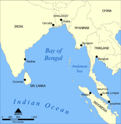
The Bay of Bengal (Bengali: বঙ্গোপসাগর [ˈbɒŋɡopoʃɑːˈgoɽ]), the largest bay in the world, forms the northeastern part of the Indian Ocean. It resembles a triangle in shape, and is bordered by Bangladesh and the Indian state of West Bengal down to the state of Tamil Nadu, India and Sri Lanka to the west and Burma (Myanmar) and the Andaman and Nicobar Islands to the east.
The Bay of Bengal occupies an area of 2,172,000 km². A number of large rivers – Padma (distributary of Ganges), Meghna (distributary of Brahmaputra), Jamuna (branch of Brahmaputra), Ayeyarwady, Godavari, Mahanadi, Krishna and Kaveri – flow into the Bay of Bengal. Among the important ports are Cuddalore, Ennore, Chennai, Karaikal, Pondicherry, Tuticorin, Kakinada, Machilipatnam, Vishakhapatnam, Paradip, Kolkata, Mongla, Chittagong and Yangon.
Contents |
Extent
The International Hydrographic Organization defines the limits of the Bay of Bengal as follows:[1]
On the East. A line running from Cape Negrais (16°03'N) in Burma through the larger islands of the Andaman group, in such a way that all the narrow waters between the islands lie to the Eastward of the line and are excluded from the Bay of Bengal, as far as a point in Little Andaman Island in latitude 10°48'N, longitude 92°24'E and thence along the Southwest limit of the Burma Sea [A line running from Oedjong Raja () in Sumatra to Poeloe Bras (Breuëh) and on through the Western Islands of the Nicobar Group to Sandy Point in Little Andaman Island, in such a way that all the narrow waters appertain to the Burma Sea].
On the South. Adam's Bridge (between India and Ceylon [Sri Lanka) and from the Southern extreme of Dondra Head (South point of Ceylon) to the North point of Poeloe Bras ().
Etymology
In the 10th century the explosion of Indianized kingdoms, led by the Chola Empire, resulted in the Bay of Bengal being known as the Chola Lake. It later came to be known as Bangal ki Khadi in Hindi after the region of Bengal.[2] Bengal comes from the Sanskrit Banga or Vanga which refers to the delta waters of the river Ganga.[3][4]
Rivers
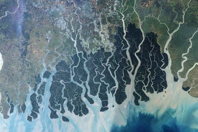
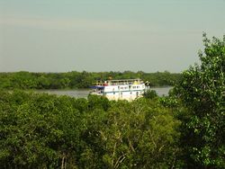
Many major rivers of India and Bangladesh flow west to east into the Bay of Bengal: in the north, the Ganges River (or Ganga), Meghna River and Brahmaputra River rivers, and in the south Mahanadi River through the Mahanadi River Delta, Godavari River, Krishna River, Irrawaddy and Kaveri River (sometimes written as Cauvery) rivers. The shortest classified river which drains into the Bay of Bengal is Cooum River at 64 km (40 mi). Brahmaputra is the 28th longest River in the World 2,948 km (1,832 mi), and it discharges into the 'Bay of Bengal' and travels through India, P.R. China and Bangladesh. The Sundarbans mangrove forest is formed at the delta of the Ganga, Brahmaputra and Meghna rivers on the Bay of Bengal. The Ayeyarwady River of Myanmar also flows into the bay and once had thick mangrove forest of its own.
Seaports
Major Bangladesh ports on the bay include Chittagong and Mongla. Major Indian ports on the bay include Kakinada, Chennai (formerly Madras), Vishakhapatnam, Kolkata (formerly Calcutta), Pondicherry and paradip. Yangon, the largest city and former capital of Myanmar is also an important port in the bay.
Islands
The islands in the bay are very numerous, including the Andaman, Nicobar and Mergui groups. The group of islands, Cheduba and others, in the north-east, off the Burmese coast, are remarkable for a chain of mud volcanoes, which are occasionally active. Great Andaman is the main archipelago or island group of the Andaman Islands, whereas Ritchie's Archipelago consists of smaller islands. Only 37 of the 572 islands and islets of the Andaman and Nicobar Islands are inhabited, or 6.5%.[5]
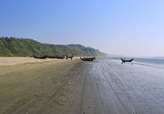
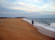
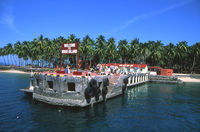
Beaches

.jpg)
| Sea Beach | Location |
|---|---|
| Cox's Bazar | Bangladesh |
| Kuakata | Bangladesh |
| St. Martin's Island | Bangladesh |
| Bakkhali | India |
| Digha | India |
| Chandipur | India |
| Puri | India |
| Waltair | India |
| Marina Beach | India |
| Ngapali | Burma |
| Arugram | Sri Lanka |
Oceanography
The Bay of Bengal is a salt water sea and is a part of the Indian Ocean. It is also the largest bay in the world by area.
Plate tectonics
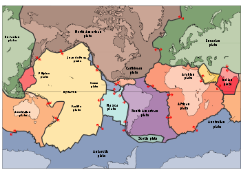
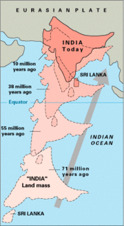
The lithosphere of the earth is broken up into what are called tectonic plates. Underneath the Bay of Bengal is the Indian Plate which is part of the great Indo-Australian Plate and is slowly moving north east. This plate meets the Burma Microplate at the Sunda Trench. The Nicobar Islands, and the Andaman Islands are part of the Burma Microplate. The India Plate subducts beneath the Burma Plate at the Sunda Trench or Java Trench. Here, the pressure of the two plates on each other increase pressure and temperature resulting in the formation of volcanoes such as the volcanoes in Myanmar, and a volcanic arc called the Sunda Arc. Sumatra-Andaman earthquake and Asian Tsunami was a result of the pressure at this zone causing a submarine earthquake which then resulted in a huge Tsunami.[7]
Marine geology
A zone 50 m wide extending from the island of Ceylon and the Coromandel coast to the head of the bay, and thence southwards through a strip embracing the Andaman and Nicobar islands, is bounded by the 100 fathom line of sea bottom; some 50 m. beyond this lies the Soo-fathom limit. Opposite the mouth of the Ganges, however, the intervals between these depths are very much extended by deltaic influence.
Swatch of No Ground is a 14 km-wide deep sea canyon of the Bay of Bengal. The deepest recorded area of this valley is about 1340 m.[8]
Marine biology, flora and fauna
The Bay of Bengal is full of biological diversity, diverging amongst coral reefs, estuaries, fish spawning and nursery areas, and mangroves. The Bay of Bengal is one of the World's 64 largest marine ecosystems.
Kerilia jerdonii is a sea snake of the Bay of Bengal. Glory of Bengal Cone (Conus bengalensis) is just one of the seashells which can be photographed along beaches of the Bay of Bengal.[10] An endangered species, the Olive Ridley sea turtle can survive because of the nesting grounds made available at the Gahirmatha Marine Wildlife Sanctuary, Gahirmatha Beach, Orissa, India. Marlin, barracuda, skipjack tuna, (Katsuwonus pelamis), yellowfin tuna, Indo-Pacific humpbacked dolphin (Sousa chinensis) , and Bryde's whale (Balaenoptera edeni) are a few of the marine animals. Bay of Bengal Hogfish (Bodianus neilli) is a type of Wrass which live in turbid lagoon reefs or shallow coastal reefs. Schools of dolphins can be seen, whether they are the bottle nose dolphin (Tursiops truncatus), Pantropical spotted dolphin (Stenella attenuata) or the spinner dolphin (stenella longirostris) . Tuna and dolphins are usually residing in the same waters. In shallower and warmer coastal waters the Irrawaddy Dolphins (Orcaella brevirostris) can be found.[11][12]
The Great Nicobar Biosphere Reserve proides sanctuary to many animals some of which include the saltwater crocodile (Crocodylus porosus) , giant Leatherback Sea Turtle (Dermochelys coriacea) , and Malayan box turtle (Cuora amboinensis kamaroma) to name a few.
Another endangered species Royal Bengal Tiger is supported by Sundarbans a large estuarine delta that holds a mangrove area in the Ganges River Delta.[13][14]
Chemical oceanography
Coastal regions bordering the Bay of Bengal are rich in minerals. Sri Lanka, Serendib, or Ratna – Dweepa which means Gem Island. Amethyst, beryl, ruby, sapphire, topaz, and garnet are just some of the gems of Sri Lanka. Garnet and other precious gems are also found in abundance in the Indian states of Orissa and Andhra Pradesh.[15]
Physical oceanography - Climate of the Bay of Bengal
From January to October, the current is northward flowing, and the clockwise circulation pattern is called the "East Indian Current." The Bay of Bengal monsoon moves in a northwest direction striking the Nicobar Islands, and the Andaman Islands first end of May, then the North Eastern Coast of India by end of June.
The remainder of the year, the counterclockwise current is southwestward flowing, and the circulation pattern is called the East Indian Winter Jet. September and December see very active weather, season varsha (or monsoon), in the Bay of Bengal producing severe Cyclones which affect Eastern India. Several efforts have been initiated to cope with Storm surge.[16]
Tropical storms and cyclones
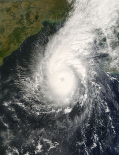
A tropical storm with rotating winds blowing at speeds of 74 miles (119 kilometres) per hour are called cyclones when they originate over the Bay of Bengal; they are hurricanes in the Atlantic.[17] Between 100,000 and 500,000 residents of East Pakistan (Bangladesh) were killed because of the 1970 Bhola cyclone.
- 2010, Severe Cyclonic Storm Laila
- 2008, Very Severe Cyclonic Storm Nargis
- 2007, Very Severe Cyclonic Storm Sidr
- 2006, Very Severe Cyclonic Storm Mala
- 2006, September Typhoon Xangsane
- 2004, November Typhoon Muifa
- 2002, May Tropical Cyclone 2B
- 1991, April Bangladesh cyclone
- 1989, November Typhoon Gay
- 1985, May Tropical Storm One (1B)
- 1982, April Cyclone One (1B)
- 1982, May Tropical Storm Two (2B)
- 1982, October Tropical Storm Three (3B)
- 1981, December Cyclone Three (3B)
- 1980, October Tropical Storm One (1B)
- 1980, December Unknown Storm Four (4B)
- 1980, December Tropical Storm Five (5B)
- 1971, Cyclone Orissa
- 1970, November Bhola cyclone
Historic sites
- The remains of Sri Vaisakheswara Swamy temple lies under the Bay of Bengal. Spokespersons from Andhra University Centre for Marine Archaeology say the temple may be located opposite the Coastal Battery.[18]
- Seven Pagodas of Mahabalipuram is the name for Mahabalipuram. Mahabalipuram's Shore Temple was constructed in the 8th century AD and myth has it that six other temples were also built here.
- Another historic site which has been preserved is Vivekanandar Illam. It was constructed in 1842 by the Ice King Frederic Tudor to store and market ice year round. In 1897, Swami Vivekananda famous lectures were recorded here at Castle Kernan. The site is an exhibition devoted to Swami Vivekananda and his legacy.
- Konark is the home of the Sun Temple or Black Pagoda. This Brahman sanctuary was built of black granite mid 1200 AD and has been declared a World Heritage Site.
- Ramanathaswami Temple located at Dhanushkodi, where the Bay of Bengal and the Indian Ocean come together.[19]
- Also the site of the well-known Butterknife Pirates (of the Bay of Bengal), who would ravage souls and celebrate their swashbuckling with champagne.
Economy
One of the first trading ventures along the Bay of Bengal was The Company of Merchants of London Trading into the East Indies more commonly referred to as British East India Company. Gopalpur was one of their main trading centers. Other trading companies along the Bay of Bengal shorelines were English East India Company and French East India Company.[20]
BIMSTEC Bay of Bengal Initiative for MultiSectoral Technical and Economic Cooperation (BIMSTEC) supports free trade internationally around the Bay of Bengal between Bangladesh, Bhutan, India, Myanmar, Nepal, Sri Lanka, and Thailand.
The Sethusamudram Shipping Canal Project is a new venture proposed which would create a channel for a shipping route to link the Gulf of Mannar with the Bay of Bengal. This would connect India east to west without the necessity of going around Sri Lanka.
Thoni and catamaran fishing boats of fishing villages thrive along the Bay of Bengal shorelines. Fishermen can catch between 26 and 44 species of marine fish.[21] In one year, the average catch is 2 million tons of fish from the Bay of Bengal alone.[22]
Strategic importance
To Bangladesh
Being Bangladesh's only sea boundary, the Bay of Bengal has a significant role in the country. Bangladesh navy performs annual exercise in the bay [23] and exercise with international navy is also frequent. The Bangladesh navy's last joint exercise with the US navy was held on early 2009.[24]
To China
Rumor exists that China has a naval base in Myanmar's Coco island of Bay of Bengal. [25]
To India
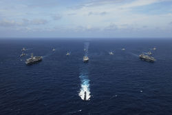
The Bay of Bengal is strategically crucial for India because of the presence of outlying islands, namely Andaman islands and Nicobar islands and several major ports such as Kolkata, Chennai, Vizag, and Tuticorin along its coast with the Bay of Bengal. Much of the naval operations of the 1971 Indo-Pakistani War took place in the Bay of Bengal.[26]
The growing influence of China, due to support provided by Myanmar, has created geo-political implications for India.[27] India has held several major naval exercises with friendly countries, especially United States, to counter increasing Chinese presence in the Indian Ocean.[28][29] The largest ever wargame in Bay of Bengal, known as Malabar 2007, was held in 2007 and naval warships from India, US, Singapore, Japan and Australia took part in it. This exercise was widely viewed as "strategic encirclement of China".[28] India has forged naval cooperation agreements with Malaysia, Thailand and Indonesia to increase its strategic reach in the region.[30] India also established Far Eastern Naval Command off Port Blair to increase surveillance in the adjoining Andaman Sea.[31]
The potential of natural gas exploitation also makes the Bay of Bengal important for India, Bangladesh and Myanmar.[30] Disputes over rights of some oil and gas blocks have caused brief diplomatic spats between India and Bangladesh.[32] The disputed maritime boundary between Bangladesh and Myanmar has twice resulted in military tensions, in 2008 and 2009. Myanmar and Bangladesh are currently pursuing a settlement to the boundary dispute through the International Tribunal on the Law of the Sea,[33] while India and Bangladesh are working towards a settlement using an arbitrator.
Environmental hazards
Pollution
The Asian brown cloud, a layer of air pollution that covers much of South Asia and the Indian Ocean every year between January and March, and possibly also during earlier and later months, hangs over the Bay of Bengal. It is considered to be a combination of vehicle exhaust, smoke from cooking fires, and industrial discharges.[34]
History
Northern Circars occupied the western coast of the Bay of Bengal and is now considered to be India's Madras state. The Kakatiya dynasty reached the western coastline of the Bay of Bengal between the Godavari and the Krishna rivers. Kushanas about the middle of the 1st century AD invaded northern India perhaps extending as far as the Bay of Bengal. Chola dynasty (9th century to 12th century) when ruled by Rajaraja Chola I occupied the western coastline of the Bay of Bengal circa AD 1014 Chandragupta Maurya extended the Maurya Dynasty across Northern India to the Bay of Bengal. Hajipur was a stronghold of Portuguese Pirates. In the 16th century the Portuguese built trading posts in the North of the Bay of Bengal at Chittagong (Porto Grande) and Satgaon (Porto Pequeno).[35]
British penal colony
Cellular Jail or "Black Waters" built in 1896 on Ross Island, a part of the Andaman Island Chain. As early as 1858 this island was used as a British penal colony for political prisoners facing life imprisonment.
Marine archaeology
Maritime archaeology or marine archaeology is the study of material remains of ancient peoples. A specialized branch, Archaeology of shipwrecks studies the salvaged artifacts of ancient ships. Stone anchors, amphorae shards, elephant tusks, hippopotamus teeth, ceramic pottery, a rare wood mast and lead ingots are examples which may survive the test of time for archaeologists to study and place the salvaged findings into a time line of history. Coral reefs, tsuanamis, cyclones, mangrove swamps, battles and a criss cross of sea routes in a high trading area combined with pirating have all contributed to shipwrecks in the Bay of Bengal.[36]
Famous ships and shipwrecks
- 1778 to 1783 The Naval operations in the American Revolutionary War or American War of Independence ranged as far as the Bay of Bengal.
- c1816 Mornington Ship burned in the Bay of Bengal[37]
- 1850 American clipper brig Eagle is supposed to have sunk in a Bay of Bengal[38]
- American Baptist missionary Adoniram Judson, Jr. died April 12, 1850 and was buried at sea in the Bay of Bengal.
- 1855 The Bark "Incredible" struck on a sunken rock in the Bay of Bengal[39]
- 1865, a gale dismasted the Euterpe while traversing the Bay of Bengal typhoon.
- 1875 Veleda 76 m (250 ft) long and 15 m (50 ft) wide is a part of a current salvage operation.[40]
- 1942 Japanese cruiser Yura of the Second Expeditionary Fleet, Malay Force attacked merchant ships in the Bay of Bengal.
- 1971 December 3 - It was claimed that Indian Navy destroyer INS Rajput sunk the Pakistan Navy submarine PNS Ghazi off of Vishakapatnam, in Bay Of Bengal List of naval battles
See also
References
- ↑ "Limits of Oceans and Seas, 3rd edition". International Hydrographic Organization. 1953. http://www.iho-ohi.net/iho_pubs/standard/S-23/S23_1953.pdf. Retrieved 7 February 2010.
- ↑ Map of the Bay of Bengal URL accessed January 22, 2007
- ↑ Bengal Love To Know 1911 URL accessed January 21, 2007
- ↑ "Kashmere: Brahman Mahatma Of the Lunar Race. The struggle between the Lunar and Solar Dynastys/Cast". http://logos_endless_summer.tripod.com/id97.html. Retrieved 2007-01-21.
- ↑ The long stretch of sand glistening like silver dust URL accessed January 23, 2007
- ↑ "World's longest beach hidden in Bangladesh". The Sydney Morning Herald. January 31, 2007. http://www.smh.com.au/news/travel/the-worlds-longest-beach/2007/01/31/1169919381993.html.
- ↑ Tsunami URL access January 21, 2007
- ↑ Morphological features in the Bay of Bengal URL accessed January 21, 2007
- ↑ Pasha, Mostafa Kamal; Siddiqui, Neaz Ahmad (2003). "Sundarbans". In Islam, Sirajul. Banglapedia: national encyclopedia of Bangladesh. Dhaka: Asiatic Society of Bangladesh. ISBN 9843205766. http://banglapedia.net/HT/S_0602.HTM.
- ↑ Phillip Colla Natural History Photography URL accessed Janauary 21, 2007
- ↑ Naturalist: On the swatch of no ground: Mashida R Haider goes to the Bay of Bengal and comes back full of the marine life there URL accessed January 21, 2007
- ↑ CMS: Stenella attenuata, Pantropical spotted dolphin URL accessed January 21, 2007
- ↑ 17 Bay of Bengal URL accessed January 21, 2007
- ↑ Zipcode Zoo Bodianus neilli (Bay of Bengal Hogfish) URL accessed January 21, 2007
- ↑ http://www.aringthing.com/promise_rings.htm
- ↑ Glossary of Physical Oceanography Ba-Bm URL accessed January 21, 2007
- ↑ Forces of Nature—Natural Disaster Fast Facts (National Geographic) URL accessed January 22, 2007
- ↑ Morien Institute - underwater discoveries news archive - January - June, 2006 "Sri Vaisakheswara still lies underwater" URL accessed January 22, 2007
- ↑ Ramayana URL accessed January 21, 2007
- ↑ Nabataea: Trade on the Bay of Bengal URL accessed January 21, 2007
- ↑ Globally Important Agricultural Heritage Systems (GIAHS) URL accessed January 21, 2007
- ↑ LME 34 Bay of Bengal URL access January 21, 2007
- ↑ [1]
- ↑ [2]
- ↑ [3]
- ↑ http://www.rediff.com/news/2006/dec/26claude.htm
- ↑ http://www.burmadebate.org/archives/spring01strategic.html
- ↑ 28.0 28.1 http://www.globalpolitician.com/23382-india
- ↑ http://www.voanews.com/english/archive/2007-09/2007-09-10-voa15.cfm?CFID=23265195&CFTOKEN=84466582
- ↑ 30.0 30.1 http://www.atimes.com/atimes/South_Asia/GA25Df05.html
- ↑ http://japanfocus.org/products/topdf/1610
- ↑ http://www.southasiaanalysis.org/%5Cpapers19%5Cpaper1877.html
- ↑ http://www.nbr.org/publications/element.aspx?id=449
- ↑ EO Natural Hazards: Smog over the Bay of Bengal URL accessed January 21, 2007
- ↑ The Portuguese in Bengal. History of Ugolim (Hoogli), Meliapore ... URL accessed January 21, 2007
- ↑ Marine Archaeology in India URL accessed January 22, 2007
- ↑ Shipwrecks 1816-1818 URL accessed January 23, 2007
- ↑ The Maritime Heritage Project: Gold Rush Ships, Passengers, Captains URL accessed January 23, 2007
- ↑ Shipping Notes from the 1800s - P.E.I. URL accessed January 23, 2007
- ↑ Diving-News.com » Wrecks URL accessed January 23, 2007
Further reading
- The Maritime Boundary Dispute Between Bangladesh and Myanmar: Motivations, Potential Solutions, and Implications by Jared Bissinger (Asia Policy, July 2010)
External links
- 487 V. Suryanarayan, Prospects for a Bay of Bengal Community
- Arabian Sea: depth contours and undersea features - Map/Still - Britannica Concise
- Bay of Bengal - HighBeam Encyclopedia
Sources
![]() This article incorporates text from a publication now in the public domain: Chisholm, Hugh, ed (1911). Encyclopædia Britannica (Eleventh ed.). Cambridge University Press.
This article incorporates text from a publication now in the public domain: Chisholm, Hugh, ed (1911). Encyclopædia Britannica (Eleventh ed.). Cambridge University Press.
|
|||||
|
||||||||||||||||||||
|
|||||||||||